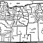
Oregon Counties Map – 1941 Linn Genealogical Society Posted on 2012-05-03 by Site Admin2012-05-11 A Map of the State of Oregon and county boundaries as delineated in 1941. Continue reading →
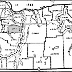
Oregon Counties Map – 1893 Linn Genealogical Society Posted on 2012-05-03 by Site Admin2012-05-11 A Map of the State of Oregon and county boundaries as delineated in 1893. Continue reading →
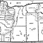
Oregon Counties Map – 1874 Linn Genealogical Society Posted on 2012-05-03 by Site Admin2012-05-11 A Map of the State of Oregon and county boundaries as delineated in 1874. Continue reading →
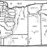
Oregon Counties Map – 1865 Linn Genealogical Society Posted on 2012-05-03 by Site Admin2012-05-11 A Map of the State of Oregon and county boundaries as delineated in 1865. Continue reading →
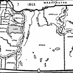
Oregon Counties Map – 1862 Linn Genealogical Society Posted on 2012-05-03 by Site Admin2012-05-11 A Map of the State of Oregon and county boundaries as delineated in 1862. Continue reading →
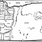
Oregon Counties Map – 1856 Linn Genealogical Society Posted on 2012-05-03 by Site Admin2012-05-10 A Map of the State of Oregon and county boundaries as delineated in 1856. Continue reading →
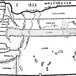
Oregon Counties Map – 1853 Linn Genealogical Society Posted on 2012-05-03 by Site Admin2012-05-11 A Map of the State of Oregon and county boundaries as delineated in 1853. Continue reading →
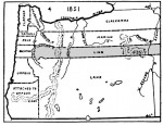
Oregon Territory Map – 1851 Linn Genealogical Society Posted on 2012-05-03 by Site Admin2012-05-11 A Map of the Oregon territory and county boundaries as delineated in 1851. Continue reading →
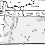
Oregon Territory Map – 1847 Linn Genealogical Society Posted on 2012-05-03 by Site Admin2012-05-11 A Map of the Oregon territory and county boundaries as delineated in 1847. Continue reading →
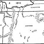
Oregon Territory Map – 1845 Linn Genealogical Society Posted on 2012-05-03 by Site Admin2012-05-11 A Map of the Oregon territory and county boundaries as delineated in 1845. Continue reading →